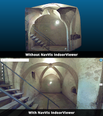
NavVis IndoorViewer Upgrade Automatically Renders 360° Immersive Imagery from E57 Point Clouds
November 1, 2018 by Susan Smith
GISCafe Voice spoke with Lisa Cali, Senior Product Manager, IndoorViewer about NavVis’s latest software upgrade to their web-based application NavVis IndoorViewer. A provider of indoor spatial intelligence technology, NavVis is now able to automatically convert E57 point cloud files into interactive, realistic 360° walkthroughs, with the latest software upgrade to IndoorViewer.


